

Distance: 4.1 km
Average duration) : 30min
Level: Easy-to-use
La Chapelle-Erbree
PR®
Yellow PR® markings and green arrow n°44, marked clockwise
Possibility to walk along the south shore of the body of water towards the dam to the west, towards Bourgon to the east or to cross the footbridge at La Hunaudaie to reach the north shore (circuit 72). Variant of the route


4 km including 1,6 km of road, signposted clockwise.
The cultivation of hemp in the countryside in the XNUMXth and XNUMXth centuries considerably enriched the country of Vitré. La Chapelle-Erbrée had many exchanges with other towns such as Saint-M'Hervé or Vitré.
Your itinerary
La Chapelle-Erbree
4 km including 1,6 km of road, signposted clockwise.
The cultivation of hemp in the countryside in the XNUMXth and XNUMXth centuries considerably enriched the country of Vitré. La Chapelle-Erbrée had many exchanges with other towns such as Saint-M'Hervé or Vitré.
The cultivation of hemp in the countryside in the XNUMXth and XNUMXth centuries considerably enriched the country of Vitré. La Chapelle-Erbrée had many exchanges with other towns such as Saint-M'Hervé or Vitré.
1
Step 1
The town hall of La Chapelle-Erbrée is housed in a building built in 1905 and most surprising for its neo-Gothic appearance. The Château du Bourg (1871), work of the architect Jacques Mellet who also designed the Saint-Martin church in Vitré and many other buildings in the region.
2
Step 2
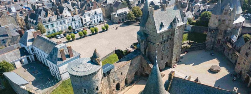
On 150 hectares, you will taste all the pleasures of sailing, windsurfing, rowing, swimming, and the beach. Shaded picnic areas are provided. The view of the fortified Château des Nétumières (XNUMXth century) is charming.
3
Step 3
Departure from the variant